
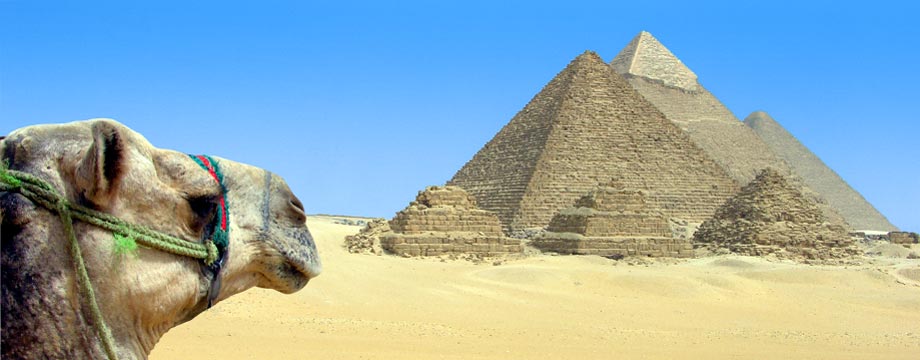
Archaeology and Ancient History

Gobekli Tepe
The World’s First Temple, Gobeklitepe … a pre-historic site, about 15 km away from the city of Sanliurfa, Southeastern Turkiye. What makes Gobeklitepe unique in its class is the date it was built, which is roughly twelve thousand years ago, circa 10,000 BC.

Archaeologically categorised as a site of the Pre-Pottery Neolithic A Period (c. 9600–7300 BC) Göbeklitepe is a series of mainly circular and oval-shaped structures set on the top of a hill. Excavations began in 1995 by Prof. Klaus Schmidt with the help of the German Archeological Institute. There is archelological proof that these installations were not used for domestic use, but predominantly for ritual or religous purposes. Subsequently it became apparent that Gobeklitepe consists of not only one, but many of such stone age temples. Furthermore, both excavations and geo magnetic results revealed that there are at least 20 installations, which in archeological terms can be called a temple. Based on what has been unearthed so far, the pattern principle seems to be that there are two huge monumental pillars in the center of each installation, surrounded by enclosures and walls, featuring more pillars in those set-ups.


All pillars are T-shaped with heights changing from 3 to 6 meters. Archeologists interpret those T-shapes as stylized human beings, mainly because of the depiction of human extremities that appear on some of the pillars. What also appears on these mystical rock statues, are carvings of animals as well as abstract symbols, sometimes picturing a combination of scenes.


Foxes, snakes, wild boars, cranes, wild ducks are most common. Most of these were carved into the flat surfaces of these pillars. Then again, we also come across some three-dimensional sculptures, in shape of a predator depicting a lion, descending on the side of a T-pillar.

The unique method used for the preservation of Gobeklitepe has really been the key to the survival of this amazing site. Whoever built this magnificent monument, made sure of its survival along thousands of years, by simply backfilling the various sites and burying them deep under, by using an incredible amount of material and all these led to an excellent preservation.

This site has some great photos: http://www.ancient-wisdom.co.uk/turkeygobekli.htm
E.I.R.S. researcher Sema Yilmaz has recently provided a preliminary report of Gobekli Tepe prior to her arrival on site.
See this report here:
http://independent.academia.edu/EarthsInternationalResearchSociety/Papers/1961105/Gobekli_Tepe_Report
Other Nearby Sites of Interest:
Karahan Tepe, a site only discovered in the late 1990s and still awaiting full excavation. This is located near Sogmatar on the Harran Plain, and dates back 11,000 years at least. Already a large number of T-Shaped pillars and stone rows have been uncovered here.
Karahan Tepe lies 60 km east from Urfa in an area called Tektek Daglari. Some 266 in situ pillars (Like the Göbekli pillars…only smaller) cover the field and are visible 50-60 cm above ground level. The rest of the pillars are still covered under the earth.
As there is no evidence of habitation; the structures are interpreted as temples. After 8000 BC, the site was abandoned and purposely covered up with soil. (1) It is thought that the hill top was a site of pilgrimage for communities within a radius of roughly a hundred miles. The tallest stones all face southeast,
In the Jan. 18 issue of the journal ‘Science‘, German archaeologist Klaus Schmidt is interviewed about his work at the 11,000-year-old site of Gobekli Tepe (“navel hill”) in Turkey.
According to Andrew Curry, the author of the Sciencearticle, Gobekli Tepe is situated on the most prominent hilltop for miles around. It consists of at least 20 underground rooms that contain a number of T-shaped stone pillars that are 8 feet tall and weigh about 7 tons. The pillars are engraved with images of animals, including leopards, snakes and spiders.
This is not a place where people lived. It’s as far away from water as you can get in this region. Instead, it’s a place of ceremony. And, according to Schmidt, it’s “the first manmade holy place.”
Göbekli Tepe – Video: Modeling Göbekli Tepe – Pictures, More From National Geographic Magazine.
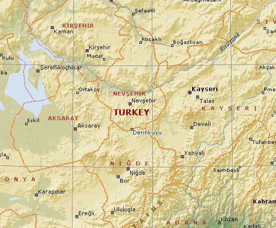
Derinkuyu: (Underground City).
Carved from the living rock, Derinkuyu is one of five inter-connected underground complexes with a total estimated capacity of 100,000 people.
The historical region of Cappadocia where Derinkuyu is situated, contains several historical underground cities, carved out of a unique geological formation, many of which were largely re-used by early Christians as hiding places.
Over 200 underground cities at least two levels deep have been discovered in the area between Kayseri and Nevsehir, with around 40 of those having at least three levels. The cities at Derinkuyu and Kaymaklı are two of the best examples of underground dwellings. (2)
(Map of site – How to get there)
Derinkuyu (‘Deep Well’): Melagobia, Malakopi.
The largest of the Cappadocia underground complexes is multi-storey (18 storeys, 85m deep), with fresh flowing water, ventilation shafts and individually separated living quarters or ‘apartments’, shops, communal rooms, wells, tombs, arsenals and escape routes. It has the potential to house up to 20,000 people. The complex was air conditioned throughout, with 52 air shafts discovered so far, one of which is 55m deep.. some wells were not connected with the surface, presumably in order to protect the dwellers from poisoning during raids. (1)
Derinkuyu underground settlement was opened to visitors in 1965, but so far only 10% can be visited. Entry is through tunnels that force one to almost crawl on occasion in order to force invaders into single file… One tunnel on the third level of Derinkuyu is said to connect to the nearby underground city of Kaymakli (5km distant). (3)
The massive circular doors – These circular doors are visible at all the local underground sites. They were rolled across the passages and sealed the citadels from the inside. At Derinkuyu Each level could also be sealed individually.
When were they constructed?
Wikipedia says of it: ‘First built by the Phrygians in the 8th-7th centuries B.C according to the Turkish Department of Culture, the underground city at Derinkuyu was enlarged in the Byzantine era. The oldest written source about underground cities is the writings of Xenophon (ca. 431 – 355 BC). In his Anabasis he writes that the people living in Anatolia had excavated their houses underground, living well in accommodations large enough for the family, domestic animals, and supplies of stored food’.
(Ref: http://en.wikipedia.org/wiki/Derinkuyu)
Alternatively, they were believed to have ‘been constructed at around 1,400 BC by the Hittites’.
http://chopsueyblog.wordpress.com
A Hittite connection is confirmed by archaeology, but the exact date remains elusive:
In origin, the cities are thought to date back to Hittite times at least (1900–1200 BC). Hittite-style seals have been found during excavations and other Hittite remains, such as a lion statue, have turned up in the area. It is possible that the underground rooms were used as shelters during the attacks of 1,200 BC, when the Hittite Empire was destroyed by invaders from Thrace. Later the complexes were enlarged by other civilizations, and the presence of missionary schools, churches and wine cellars would seem to indicate that they were used by Christian communities.
There are another 200 subterranean settlements in the area although only a few are open to the public. (2)
Kaymakli (Ozluce) Roughly 10 kilometres to the north of Derinkuyu, is smaller and less excavated but 5 levels are accessible.

Ozluce Underground settlement is different from the others in terms of its geological formation and architectural features. The underground settlement has tufa of different colours. There is only one floor in this underground settlement which has not been completely opened; however, it covers a very large area.
At the entrance is a place with two intertwining arches made of basalt. Access to the main tufa stone can be gained through a 15 m long passage, made of rubble stone. The stone places, which lead to the underground settlement, are more recent than the rock hollowed places that form the underground settlement. At the end of this passage there is a millstone door which is made of hard granite and is 1.75 m in diameter.
Being the largest area in the underground settlement, the main space at the entrance consists of two parts. To the right of the main space are storage rooms, and to the left are living areas. On the sides of the long corridors are cell-like rooms and on the floor are traps. (1)
Tatlarin (The Castle). – Christianised underground settlement.
 |
|---|
The village of Tatlarin, located 10 km north of the town of Acigol, is one of the interesting places in Cappadocia because of both its underground settlement and churches and the architecture of its houses. Its underground settlement, located on the hill called ‘the castle’ by the locals of the village, was first discovered in 1975 and opened to the public in 1991. The size of the chambers in the underground settlement, only two floors of which can be visited; the presence of the toilets, which also can only be found at the Guzelyurt Underground Settlement; the abundance of the depots for food and of the churches make one think that this place was either a garrison or a monastic complex rather than an underground settlement. (1)
Özkonak (Avanos). A smaller version than that at Derinkuyu. This is where E.I.R.S. researcher Sema Yilmaz is at the moment.

Built on the northern slopes of Mt. Idis about 14 km northeast of Avanos in Turkey has many strata made up of volcanic granite. The larger areas of the city are connected to each other by tunnels. Özkonak had a built in communication system of pipes to each of its levels, unlike Kaymakli and Derinkuyu which have no such communication systems. Each carved out room had ventilation provided by holes when the city was closed against enemies.
Özkonak was discovered in 1972 by a local farmer named Latif Acar, who was curious about where his excess crop water was disappearing to. Latif discovered an underground room which, when later excavated, revealed a whole city which could house an incredible 60,000 people for up to three months. Although only four floors are now open, the complex contains a total of ten floors, to a depth of 40m.
(Other Prehistoric Turkish sites)
References:
1). http://www.cappadociaonline.com/ 2). http://en.wikipedia.org/wiki/Derinkuyu 3). Tracy T. Twyman, Richard Metzger. The Arcadian Mystique. 2005. Dragon Key Press.Other Ancient Sites in Turkey:
Ashikli Hüyük.
Çatal Hüyük.
Çayönu.
Derinkuyu.
Göbekli Tepe.
Metsamor (Armenia).
Nevali Çori.
Troy.
Sources and image credits : http://www.ancient-wisdom.co.uk/turkeyderinkuyu.htm http://gobeklitepe.infoMaccu Pichu

Photograph by Frank Tophoven, laif/Redux
Brief Description
Machu Picchu stands 2,430 m above sea-level, in the middle of a tropical mountain forest, in an extraordinarily beautiful setting. It was probably the most amazing urban creation of the Inca Empire at its height; its giant walls, terraces and ramps seem as if they have been cut naturally in the continuous rock escarpments. The natural setting, on the eastern slopes of the Andes, encompasses the upper Amazon basin with its rich diversity of flora and fauna.

Long Description
Machu Picchu bears, with Cuzco and the other archaeological sites of the valley of the Urubamba (Ollantautaybo, Runcuracay, Sayacmarca, Phuyupamarca, Huiñay Huayna, Intipucu, etc.) a unique testimony to the Inca civilization. Cuzco and the old villages still retain traces of land occupation from the Inca Empire to preserve, in a more global manner, an archaeological heritage which has become susceptible to the effects of urbanization. Furthermore, Macchu Picchu is an outstanding example of man’s interaction with his natural environment.
Standing 2,430 m above sea level, in the midst of a tropical mountain forest in an extraordinarily beautiful setting, Machu Picchu was probably the most amazing urban creation of the Inca Empire at its height. Its giant walls, terraces and ramps seem as if they have been cut naturally in the continuous rock escarpments. The natural setting, on the eastern slopes of the Andes, encompasses the upper Amazon basin with its rich diversity of flora and fauna.
Machu Picchu covers 32,500 ha in some of the scenically most attractive mountainous territory of the Peruvian Andes. As the last stronghold of the Incas and of superb architectural and archaeological importance, Machu Picchu is one of the most important cultural sites in Latin America; the stonework of the site remains as one of the world’s great examples of the use of a natural raw material to provide outstanding architecture which is totally appropriate to the surroundings. The surrounding valleys have been cultivated continuously for well over 1,000 years, providing one of the world’s greatest examples of a productive man-land relationship; the people living around Machu Picchu continue a way of life which closely resembles that of their Inca ancestors, being based on potatoes, maize and llamas. Machu Picchu also provides a secure habitat for several endangered species, notably the spectacled bear, one of the most interesting species in the area. Others animals include: dwarf brocket, the otter, long-tailed weasel, pampas cat and the vulnerable ocelot, boa, the Andean cock of the rock, and the Andean condor.
The natural vegetation is of humid and very humid lower montane forest of the subtropical region, mainly with genera and ferns of the Cyathea and palms.
Set on the vertiginous site of a granite mountain sculpted by erosion and dominating a meander in the Rio Urubamba, Machu Picchu is a world renowned archaeological site. The construction of this amazing city, set out according to a very rigorous plan, comprises one of the most spectacular creations of the Inca Empire. It appears to date from the period of the two great Incas, Pachacutec Inca Yupanqui (1438-71) and Tupac Inca Yupanqui (1472-93). The function of this city situated at least 100 km from the capital, Cuzco, has not been formulated which are not verifiable given the absence of written documentation and sufficiently explicit material evidence.
Without making a judgement as to their purpose, several quite individual quarters may be noted in the ruins of Machu Picchu: a quarter ‘of the Farmers’ near the colossal terraces whose slopes were cultivated and transformed into hanging gardens; an ‘industrial’ quarter; a ‘royal’ quarter and a ‘religious’ quarter. Inca architecture reveals itself here in all of its force with the titanic earthen works which multiplied the platforms, levelled the rocky relief, constructed ramps and stairways and literally sculpted the mountain whose cyclopean constructions appear to be a prolongation of nature.
Source: UNESCO/CLT/WHC
Species
The species listed below represent a small sample of iconic and/or IUCN Red Listed animals and plants found in the property. Clicking on the number in brackets next to the species will reveal other World Heritage Properties in which a species has been identified. These species are identified in an effort to better communicate the biological diversity contained within World Heritage properties inscribed under criteria ix and/or x.
- Leopardus colocolo / Pampas Cat
- Leopardus pardalis / Ocelot (5)
- Lutra longicaudis / Neotropical Otter (3)
- Mazama chunyi / Peruvian Dwarf Brocket
- Mustela frenata / Long-tailed Weasel
- Penelope montagnii / Andean Guan
- Rupicola peruviana / Andean Cock-of-the-rock (2)
- Tremarctos ornatus / Spectacled Bear (3)
- Vultur gryphus / Andean Condor (2)
Media
 Historic Sanctuary of Machu Picchu (UNESCO/NHK)
- NHK World Heritage 100 Series [Windows Media required]
Activities
News
- Damage evaluated at Machu Picchu after torrential rains Feb 12, 2010
- Torrential rains cause death and damage at Peruvian World Heritage sitesJan 28, 2010
- World Heritage Committee requests close surveillance of Bordeaux, Machu Picchu, Timbuktu and Samarkand Jul 10, 2008
- UNESCO joins United Nations effort in response to Peruvian earthquakeAug 21, 2007
- UNESCO sends mission to assess the state of conservation of Machu Picchu World Heritage Site Apr 19, 2007
- Fire At Machu Picchu, Peru, 6-11 September Sep 12, 1997
Links
 View photos from OUR PLACE the World Heritage collection
Miscellaneous Documents
Pumapunku, also called “Puma Pumku” or “Puma Puncu”, is part of a large temple complex ormonument group that is part of the Tiwanaku Site near Tiwanaku, Bolivia. In Aymara, its name means, “The Door of the Cougar”. The processes and technologies involved in the creation of these temples are still not fully understood by modern scholars. Our current ideas of the Tiwanaku culture hold that they had no writing system and also that the invention of the wheel was most likely unknown to them. The architectural achievements seen at Pumapunku are striking in light of the presumed level of technological capability available during its construction. Due to the monumental proportions of the stones, the method by which they were transported to Pumapunku has been a topic of interest since the temple’s discovery.
MYSTIC PLACES – PUMAPUNKU ( PUMA PUNKA )
Puma Punku (Puma Punka)Puma Punku, truly startles the imagination. It seems to be the remains of a great wharf (for Lake Titicaca long ago lapped upon the shores of Tiahuanaco) and a massive, four-part, now collapsed building. One of the construction blocks from which the pier was fashioned weighs an estimated 440 tons (equal to nearly 600 full-size cars) and several other blocks laying about are between 100 and 150 tons.
Puma Punku ruins, Tiahuanaco, Bolivia
(courtesy of www.sacredsites.com and Martin Gray)The quarry for these giant blocks was on the western shore of Titicaca, some ten miles away. There is no known technology in all the ancient world that could have transported stones of such massive weight and size. The Andean people of 500 AD, with their simple reed boats, could certainly not have moved them. Even today, with all the modern advances inengineering and mathematics, we could not fashion such a structure.Just out of the aerial picture (below) to the bottom left is the site of the Puma Punku. This is another ‘temple area’ with many finely cut stones some weighing over 100 tonnes. Its position to the south of the Akapana may have been important because it gave a good view to a sacred mountain far to the east.Of course there is no certainty that this was the reason as the ancient builders left no written records.
All the legends have been handed down through the generations.
Puma Punku ruins, Tiahuanaco, Bolivia
(courtesy of www.sacredsites.com and Martin Gray)How were these monstrous stones moved and what was their purpose?
Posnansky suggested an answer, based upon his studies of the astronomical alignments of Tiahuanaco, but that answer is considered so controversial, even impossible, that it has been ignored and censured by the scientific community for fifty years.


Carved stone block at Puma Punku. This precision-made 6 mm wide
groove contains equidistant, drilled holes. It seems impossible that this
cuts were made with use of stone or copper tools.


The so-called Gate of the Sun seen at the back side.
Made of one piece of hard rock. Possibly it was a part of a large wall.
By the courtesy of http://www.inkatour.com, nr. 3696


Puma Punku doesn’t look impressive: a hill as remains of an old pyramid and a large number of megalithic block of stone on the ground, evidently smashed by a devastating earthquake. However, closer inspection shows that these stone blocks have been fabricated with a very advanced technology. Even more surprising is the technical design of these blocks shown in the drawing below. All blocks fit together like interlocking building blocks.

Source: Jean-Pierre Protzen & Stella E.Nair, “On Reconstructing Tiwanaku Architecture”, Jpurnal of the Society of Architectural Historians, Vol. 59, Nr.3, 2000, pp. 358-371

Artistic interpretation © World-Mysteries.com

Artistic interpretation © World-Mysteries.com
A wall of the Akapana, the pyramid of Tiahuanacu, shows similar modular design. Blocks that are piled one on top of the other but the underside of the upper stone is cut at an angle. The top of the standing stone is cut at the same angle, as shown on the figure below.

Source: Jean-Pierre Protzen & Stella E.Nair, “On Reconstructing Tiwanaku Architecture”, Jpurnal of the Society of Architectural Historians, Vol. 59, Nr.3, 2000, pp. 358-371
This stone technology plainly contradicts what official archaeology suggests about the general state of development of the ancient peoples of South-America.

Source:
“Die Ruinenstätte von Tiahuanaco im Hochlande des alten Peru”
(The Ruins of Tiahuanaco in the Highlands of Ancient Peru)
1892 book about Tiahanaco written by two German
discoverers and engineers Alphons Stübel and Max Uhle
The architectural achievements seen at Pumapunku are striking in light of the presumed level of technological capability available during itsconstruction. Due to the monumental proportions of the stones, the method by which they were transported to Pumapunku has been a topic of interest since the temple’s discovery. The largest of these stone blocks is 7.81 meters long, 5.17 meters wide, averages 1.07 meters thick, and is estimated to weigh about 131 metric tons. The second largest stone block found within the Pumapunka is 7.90 meters long, 2.50 meters wide, and averages 1.86 meters thick. Its weight has been estimated to be 85.21 metric tons. Both of these stone blocks are part of the Plataforma Lítica and composed of red sandstone. Based upon detailed petrographic and chemical analyses of samples from both individual stones and known quarry sites, archaeologists concluded that these and other red sandstone blocks were transported up a steep incline from a quarry near Lake Titicaca roughly 10 km away. Smaller andesite blocks that were used for stone facing and carvings came from quarries within the Copacabana Peninsula about 90 km away from and across Lake Titicaca from the Pumapunka and the rest of the Tiwanaku Site.
More Pictures of Puma Punku


Shattered stones of the Pumapunku (Photo by Clark Erickson)

Image Source: http://www.paleoseti.com/pumapunku.htm

Image Source: http://www.paleoseti.com/pumapunku.htm

Image Source: http://www.paleoseti.com/pumapunku.htm

Image Source: http://www.paleoseti.com/pumapunku.htm
The following set coutesy of
http://www.skyscrapercity.com/showthread.php?t=886390&page=2


Here are few subject related movies from “YouTube”:
Stone Technology
The Sun Temple was constructed with huge red porphyry (pink granite) boulders. The stone quarry is named Kachiqhata (Salt Slope) and is located about 4 km (2.5 miles) away on the other side of the valley, by the upper side of the opposite south-western mountains. The boulders were carved partially in the quarries, and taken down to the valley’s bottom. In order to cross the river Quechuas constructed an artificial channel parallel to the natural river bed that served for deviating the river’s water according to conveniences. Therefore, while that water flowed through one channel the other was dry, thus stones could be taken to the other side of the valley. More over, the boulders were transported to the upper spot where the temple is erected using the inclined plane that is something like a road which silhouette is clearly seen from the valley’s bottom. They had the help of log rollers or rolling stones as wheels, South-American cameloids’ leather ropes, levers, pulleys, andthe power of hundreds and even thousands of men. Today, on the way from the quarry to the temple there are dozens of enormous stones that people know as ” tired stones” because it is believed that they could never be transported to their destination; those stones are the reason why some authors claim that the Sun Temple was unfinished when the Spanish invasion happened.


Massive, multi-sided blocks were precisely fitted together in interlocking
patterns in order to withstand the disastrous effects of earth quakes.
Scientists speculate that the masonry process might have worked like this: after carving the desired shape out of the first boulder and fitting it in place, the masons would somehow suspend the second boulder on scaffolding next to the first one. They would then have to trace out a pattern on the second boulder in order to plan the appropriate jigsaw shape that would fit the two together. In order to make a precise copy of the first boulder’s edges, the masons might have used a straight stick with a hanging plum-bob to trace its edges and mark off exact points for carving on the second boulder. After tracing out the pattern, they would sculpt the stone into shape, pounding it with hand-sized stones to get the general shape before using finger-size stones for precision sanding. Admittedly, this entire technique is merely scientific speculation. The method might have worked in practice but that doesn’t mean this is how the ancient Quechua stonemasons did it.
“How were such titanic blocks of stone brought to the top of the mountain from the quarries many miles away? How were they cut and fitted? How were they raised and put in place? Now one knows, no one can even guess. There are archaeologists, scientists, who would have us believe that the dense, hard andesite rock was cut, surfaced and faced by means of stone or bronze tools. Such an explanation is so utterly preposterous that it is not even worthy of serious consideration. No one ever has found anywhere any stone tool or implement that would cut or chip the andesite, and no bronze ever made will make any impression upon it.”
A. Hyatt & Ruth Verrill —-America’s Ancient Civilizations
Jean-Pierre Protzen thinks the Verrills was wrong. He went to Cuzco and showed how river rocks could be used as hammers to pound stones into the desired shape.
“It appears that the Inca technique of fitting the blocks together was based largely on trial and error. It is a laborious method, particularly if one considers the size of some of the huge stones at Sacsahuaman or Ollantaytambo. What should be kept in mind, however, is that time and labour power were probably of little concern to the Incas, who did not have a European notion of time and had plenty of tribute labour from conquered peoples at their disposal.”
Jean-Pierre Protzen —Scientific American —Feb. 1986

Was this monolith carved with stone tools?
Eric Von Daniken, in his series of books beginning with Chariots of the Gods theorized that the Andean stone-works were build by Alien/Gods who visited the earth long ago, bringing civilization to primitive man. The scientific community simply snickered.
Whatever one thinks of his theories, he brought to the public an awareness of the many ancient monuments on earth that seem to defy rational explanation.
Everybody who has traveled to Egypt, Mesopotamia, South America and many ancient places has seen it: the astonishing craftsmanship of these ancient stoneworkers. The precision fit of large stone blocks is eminent in both the Old and New World. It is hardly imaginable, that all of this should have been done by pure manual work alone. This very interesting link, Ancient Stone Technology, also includes theories of Professor Davidovits from the Geopolymer Institute in France.
In short, his theory is that the 2 million blocks of limestone that make up the core of the pyramid of Chufu (Cheops), have not been cut into shape, but the limestone was solved in water, brought to the building place in small portions and then the blocks were cast in situ. Even more interesting are his ideas on the precision-fit Inca walls: He puts forward a technique to soften the stone by use of acid plant extracts!
Another interesting website is STONE TECHNOLOGY. The ancient Egyptians were masters in working with stone. These pages document photographic evidence, historical research and contemporary debates on stone technology. Topics include predynastic stonewares, straight saws, circular saws, tube drilling and lathes – Photos, Research Papers and Newsgroup Debate Summaries.
More about Inca Stone Technology>>
Aramu Muru
![]()
Another similar in nature megalithic structure is Aramu Muru near the Lake Titicaca.
Lake Titicaca, on the borders of Peru and Bolivia, is where Inca legends say life on Earth was first created by Viracocha. In the center of the lake is the Island of the Sun, with an ancient, sacred temple. Nearby is Sillustani, where mysterious burial towers called chulpas were once plated with gold and held the remains of Inca royalty.
A few miles away is Aramu Muru’s Portal, a doorway-shaped niche in a stone outcropping, located in a region known as the Valley of the Spirits. The local villagers who walked with us refused to come close to the portal. They tell stories about people disappearing through the solid rock.


Photograph courtesy of SacredSites.com
Mysterious giant stone sculpture of Aramu Muru, north of Chucuito, Peru
LINKS
- Ancient mysteries: vitrified and moulded rocks HOT
- http://www.world-mysteries.com/gw_rnincas.htm
- http://www.world-mysteries.com/mpl_piscovalley.htm
- http://www.sacredsites.com/pilgrim/3/3erd.html
Martin Gray – A Spiritual journey through Latin America - ANDES WEB RING PAGE by James Q. Jacobs
- http://www.edwebproject.org/altiplano/index.html
- http://www.harunyahya.com/books/darwinism/stoneage/stoneage04.php
- http://www.skyscrapercity.com/showthread.php?t=886390&page=2
- http://www.paleoseti.com/pumapunku.htm
Don’t miss our article about Tiwanacu >>
We are currently researching this for new data. We will be updating soon.
Easter Island and current excavations


The Easter Island Statue Project (EISP) is a private research program and archive created by Jo Anne Van Tilburg, Principle Investigator and EISP founder and director, with Cristián Arévalo Pakarati, Rapa Nui artist and co-director of EISP. The profound and immediate need for conservation actions on the moai became apparent over the course of more than 20 years of subjective observation and field experience acquired by us during our island-wide archaeological survey, which was conducted in association with our Chilean and Rapa Nui colleagues.
The Easter Island Statue Project office is located at 225 Arizona Avenue, Studio 500, Santa Monica, CA, 90401. The EISP field office is located at the Mana Gallery, Petero Atamu s/n, Hanga Roa, Easter Island (Rapa Nui), Chile.

The excavation of this moai, nicknamed “Papa” by Katherin Routledge in 1914, began in spring of 2010. Quarry bedrock is visible in one of the excavation squares and the color variation on the statue’s stone surface reflects previous soil levels.
Source: Easter Island Statue Project / J. Van Tilburg

View of one statue from an excavation trench.
Source: Easter Island Statue Project / J. Van Tilburg

The back of a partially excavated statue.
Source: Easter Island Statue Project / /Colin Montgomery

Laser scannning Hoa Hakananaia at the British Museum.
Source: Easter Island Statue Project / J. Van Tilburg

Source: Easter Island Statue Project / J. Van Tilburg

Christian Fischer, Mónica Bahamondez P. and Jo Anne Van Tilburg in the Rano Raraku quarry with unexcavated statues ‘Mama’ and ‘Papa.
Source: Easter Island Statue Project / J. Van Tilburg

The statue backs are covered in petroglyphs (pictogram engravings).
Source: Easter Island Statue Project / J. Van Tilburg

Collecting samples of the various rock tools used to carve the statues on Easter Island.
Source: Easter Island Statue Project / J. Van Tilburg

The front view of one the more than 1,000 statues that dot the island, carved over an 800 year span.
Source: Easter Island Statue Project / J. Van Tilburg

Excavation progress on the statues have been steady.
Source: Easter Island Statue Project / Jo Anne Van Tilburg / Vaiheri Tuki Haoa


Located in the South Pacific, some 2300 miles (3,700 kilometers) west of South America, Easter Island is one of the most remote locations on Earth. It is a tiny island steeped in ancient mysteries. Here are found hundreds of giant heads and torsos carved from stone, known as moai. Some are up to 33 feet (10 meters) tall, and an unfinished moai is about 69 feet (21 meters) long. They boggle the imagination. How, when, and why were they carved and erected?
There are more mysteries on Easter Island than just giant heads. Easter Island is one of the few areas of the Pacific that developed an indigenous written language. The rongorongo script is a beautiful artistic creation that was carved in hieroglyphic-like characters on wooden tablets. It has yet to be definitively deciphered (although we have a compelling theory as to what it represents–see the Plasma/Ice Age page), and unfortunately nineteenth-century missionaries to Easter Island encouraged the natives to burn most of the ronogoronogo tablets.
The eighteenth-century European discoverers of Easter Island described living “giants” (men some 12 feet tall [3.65 meters] and women 10 feet tall [3 meters]). Could these stories be true? Ancient legends of giants abound throughout the world. Could there be some truth to such legends and could a relict population have persisted on Easter Island right up to European contact? Until recently such a notion might have seemed impossible, but with the discovery of a diminutive species of humans (Homo floresiensis), commonly known as “hobbits,” that persisited until relatively recent times geologically (up to the end of the last ice age, and some suggest possibly much later) perhaps the notion of a relict population of “giants” is not so crazy after all.
In January 2010 I traveled to Easter Island with my then fiancée, now wife (we married on Easter Island), for a mini geological excursion in the company of Gary Baddeley and a few other friends and colleagues. We found so many fascinating things that we really would like to return for a full-scale expedition. To that end, we are currently soliciting donors and sponsors to continue the research.
Aside from the ancient mysteries of Easter Island (also known as Rapa Nui), I must mention here how warm and generous we found all of the Rapanui people. They not only helped us with our preliminary research (and assured us that they will continue to help us upon our return), but they literally took us into their hearts, even arranging and hosting our wedding! Katie and I send out a big Thank You to everyone on Rapa Nui. We can hardly wait to return!


Sources and image credits if not listed above: http://www.foxnews.com/scitech/slideshow/2012/05/15/easter-island-statues-unearthed/#slide=10, http://www.robertschoch.com , http://whc.unesco.org/en/list/274, http://www.world-mysteries.com/mpl_PumaPunku.htm
Leave a comment
Researchers and Society Members
-
Abid Azam
-
Alexander Lauterwasser
-
Dr. Rupert Sheldrake
-
Arthur Faram
-
Dr. Aydogan Ozcan
Bob Amsterdam
Caleb Dumitry
Chris Plesco
Cornelia Kemives
Dax Slagter
Denis Jercinovic
Djani Behram
-
Mike Tate
-
Elissa Hawke
Fauzi Hyena
Fredrik Vincent
Givi Alaznis'Pireli
Hanna Karlberg Tedford
Inge Bardor
Ivo Andreev
-
Jason Verbelli
Jeno Dudas
Jessica Schab
John Sadr
Juan Rodriguez
-
Klaus Dona
-
Dr. Konstantin Meyl
Mariko Faram
M.T. Keshe
-
Michael Tellinger
-
Nada Saif
Nathan Moorrees
Oddfrid Late
Ozan Karatli
Ricky Brett
Robert Mathisen
-
Dr. Robert Schoch
Rokus Armin
-
Russ Gries
-
Sacha Stone
Sam Matthews
Sema Yilmaz
Tanja Sablic
-
Theresa M Kelly
Tom Stuckey
Lady Veronica Keen

I entirely agree with your post! I searched from google
and am looking to subscribe to your website.
Where is your RSS feed?
For the totality of facts determines what is the case, and also anything is not the case.